Unprecedented Atmospheric River Onslaught: Impacts on Northwestern US
The northwestern United States is bracing for the onslaught of multiple atmospheric rivers in the coming days, promising heavy rain, substantial snowfall, and powerful winds. This meteorological phenomenon is set to affect more than half a dozen states across the western region, triggering various winter weather alerts. An atmospheric river (AR), characterized by a plume of moisture transporting saturated air from the tropics to higher latitudes, is poised to deliver relentless rain and snow. As the Winter Storm Severity Index (WSSI) indicates, major impacts are expected in the highest elevations of the Pacific Northwest and the Rockies, potentially leading to hazardous and even impossible travel conditions.
The Nature of Atmospheric Rivers
Atmospheric rivers play a crucial role in redistributing moisture across vast geographical areas. Originating in the tropics, they transport substantial amounts of water vapor, contributing to significant precipitation events. In this instance, the focus is on the ARs set to traverse the northwestern US, spanning from Washington and Oregon to Colorado and Wyoming.
Winter Storm Severity Index (WSSI) Predictions
The WSSI serves as a valuable tool for assessing the potential severity of winter storms. In this scenario, it highlights major impacts in the Pacific Northwest and the Rockies’ highest elevations, emphasizing the likelihood of travel conditions ranging from hazardous to impossible. As these atmospheric rivers persist, a continuous cycle without sufficient recovery time raises concerns about an increased risk of flooding.
Rainfall and Snowfall Projections
Coastal areas of Oregon, Washington, and northwestern California are expected to receive substantial rainfall, ranging from 5 to 10 inches. Simultaneously, higher elevations are anticipated to accumulate significant snowfall, with projections reaching 1 to 3 feet through the weekend. This forecast has prompted an avalanche warning for specific regions in Oregon and Washington, including Stevens and Snoqualmie Passes, the West Slopes of the southern Washington Cascades, and Mt Hood. The Northwest Avalanche Center in Seattle has issued a cautionary statement, emphasizing the imminent development of very dangerous avalanche conditions and strongly advising against travel in avalanche-prone terrain.
Back-to-Back Atmospheric Rivers: An Unrelenting AR Family
The continuous onslaught of atmospheric rivers, forming what meteorologists term an “AR family,” commenced on Saturday and is expected to persist through Wednesday. The lack of respite between these systems heightens the risk of flooding, as rivers and soils have minimal time to recede to baseline levels. Chad Hecht, a research and operations meteorologist at the Center for Western Weather and Water Extremes at UC San Diego, underscores the exacerbation of hydrologic impacts in scenarios involving multiple atmospheric rivers.
Risk Levels: A Level 4 AR Event and Potential Flooding
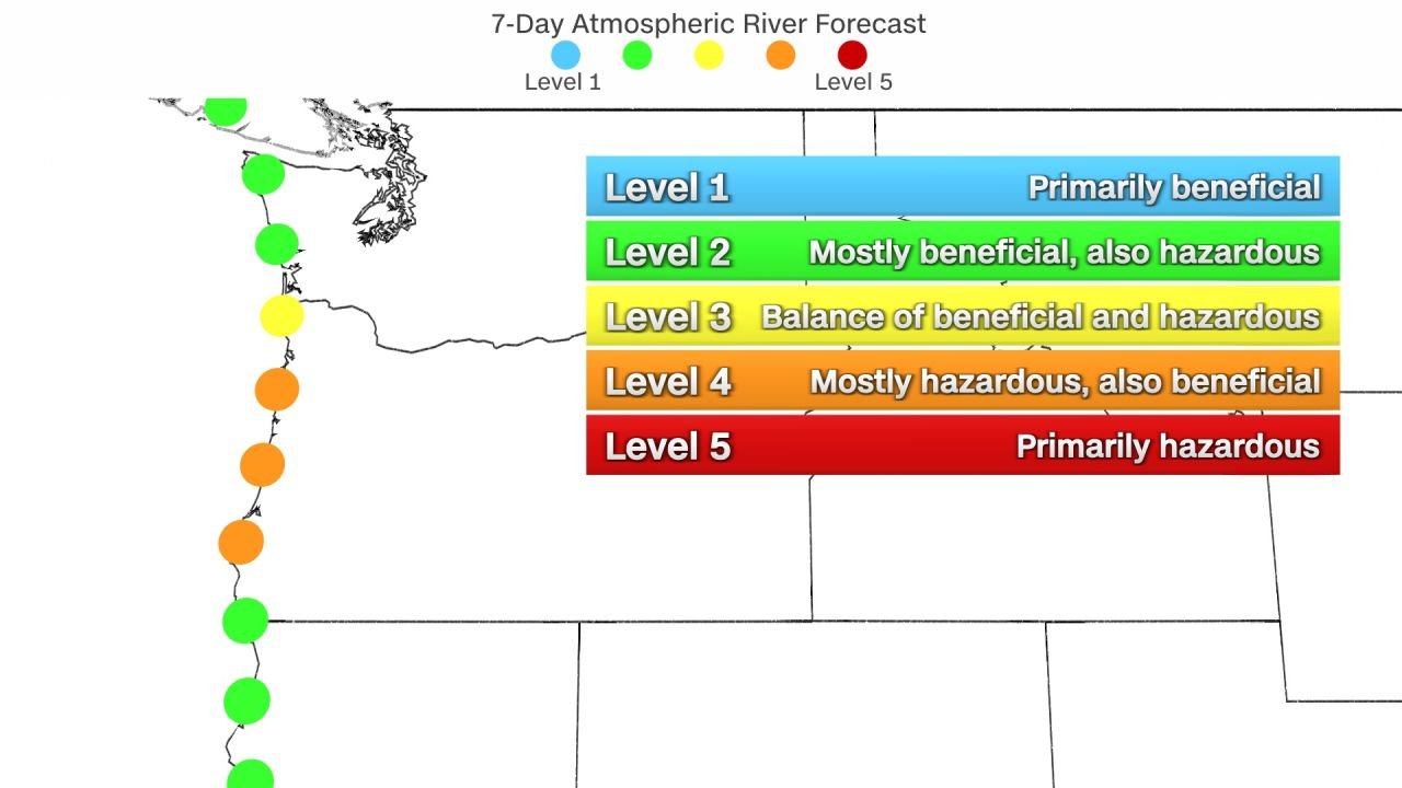
A level 4 out of 5 AR event is anticipated to impact the entire coastline of Oregon, signifying a substantial risk of flooding and other associated hazards. While not all atmospheric river events are detrimental, with levels 1 and 2 considered beneficial for water supply levels, levels 4 and 5 pose increased dangers, outweighing potential benefits. The heightened risk is attributed to enhanced rainfall during the weekend, rendering soils more vulnerable and increasing the potential for significant runoff and flooding. Initial expectations indicate high snow levels, introducing an additional risk of flooding due to snowmelt, particularly on the western-facing slopes of the Cascades.
Risk of Flooding: A Slight Risk (Level 2 out of 4)
In anticipation of excessive rainfall amounts, a slight risk for flooding (level 2 out of 4) has been issued for Sunday, Monday, and Tuesday across western Oregon and Washington. This underscores the concern for elevated runoff and flooding, especially in areas where the soils are already saturated. The forecasted precipitation levels are expected to contribute to the vulnerability of the region’s soil, amplifying the risk of flooding.
Gusty Winds and Potential Impacts
In addition to the precipitation-related threats, gusty winds reaching up to 50 mph are anticipated. These strong winds have the potential to bring down trees and power lines, leading to additional concerns for public safety and infrastructure damage.
As the northwestern US braces for the unprecedented atmospheric river onslaught, the multifaceted impacts encompass heavy rainfall, substantial snowfall, and gusty winds. The continuous nature of these atmospheric rivers, forming an AR family, raises concerns about flooding, avalanche risks, and travel safety. Meteorological agencies and experts emphasize the need for heightened awareness and preparedness in the affected regions. The evolving situation underscores the complexity of weather systems and the importance of leveraging advanced forecasting tools to mitigate the potential risks associated with severe winter weather events


